
Putt Line + GPS
Putt Line + GPS is digital green-reading plus GPS on the hole. It is the same laser-scanned putting surface that prints in a StrackaLine greens guide, shown on a phone instead of on paper. Jim Stracka invented the laser-scanned green-reading map in 2007. More than two million physical books have been sold from that work. The app is not a second map. It is the same millimeter-accurate scan: dual-view topographic slope in percent, a 1-yard / 5-yard grid, and GPS distances tee to green.
This site does not check you out. Open Putt Line + GPS on strackaline.com. If the question is paper versus a phone for a competition round, the comparison is Printed Green Book vs App.
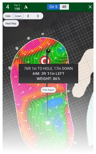
Putt Line + GPS is the StrackaLine green map and hole GPS on a phone, not a checkout on this site.
What sits in the database
The course database holds 31K+ courses. 13,000+ of those have full hyper-accurate green data. Yardage and GPS can exist on a course that does not yet have a full greens guide. Search the course the same way you would for a book: the options on that listing tell you which features are available. How to Order a Yardage Book is the walkthrough for that store search.
On a mapped green you get the same dual-view slope, grid, and orientation marks — surrounding hazards and sprinkler heads — that appear in the printed USGA greens guide. The yardage view is the hole: elevation, cover to bunkers and penalty areas, distance rings, and a compass. That split is on Yardage Book vs Green Reading Book. Tour players, 900+ NCAA teams, and 170+ industry partnerships already use this scan in books and pinsheets.
USGA scale applies to the digital map
Rule 4.3 does not care whether the map is ink or pixels. Any image of a putting green must stay at a scale no larger than 3/8 inch to 5 yards (1:480). You may not zoom a green past that scale. The device may not produce a recommended line of play based on the location of the ball. Slope in percent on a legal-size image is allowed. A start line drawn from where the ball sits is not. The USGA’s own material is at usga.org/GRM. The Rule 4.3 questions we keep on this site are on What’s Legal? – USGA Rules.
A printed USGA book cannot pinch-zoom because the ink is already at legal scale. A digital map is legal only if the image on the screen still meets those limits and you do not use the device as a recommended-line tool. How to Read a Green Book and How to Read Green Heat Maps cover how to take slope percent, the fall line, and the grid, and still pick the aim yourself.
GPS distances are not a green-reading map
A GPS-only app such as Arccos, GolfLogix, or a Bushnell unit can tell you how far you have to the green. Distance is not a green-reading map. Putt Line + GPS is GPS on the hole plus the StrackaLine scan on the putting surface. If all you need is a number to a sprinkler, those GPS products cover that job. If you need the surface between the ball and the hole, you need the laser scan.
GPS is for the shots that get you onto the green. Once you are putting, the work is the same as the printed page: orient the map, locate two points on the grid, read slope percent, pick an aim. See also the how-to video.
How to use it on a hole
Open the hole before you reach the green, or as you walk up. Orient the map to the ground the same way you would a printed page: hazards and sprinkler heads lock rotation. Locate the ball and the hole on the grid. Read slope percent between those points. Decide whether the putt runs with the fall line or across it. Then choose a start line and a pace. That last sentence is the player’s job.
Practice rounds and casual play are where a phone is often more convenient than a book. A competition that applies Rule 4.3 is where many golfers still carry the printed USGA greens guide so the scale cannot accidentally change. Decide which one belongs in the bag for that round on Printed Green Book vs App.
You cannot print a book from the app. If you want paper, search the course at the StrackaLine store and order a greens guide, yardage book, or combo. Facilities that want books in the shop use wholesale book pricing. College teams use the NCAA program.
Open Putt Line + GPS Printed book vs app
Course prep and posting a round sit on a different product: Course Prep + Stats. Other hubs are listed on Resources.
FAQ
Is a digital green map legal in a tournament?
Only if the image on the screen still meets the 3/8 inch to 5 yard scale, you do not zoom the green past that limit, and the device does not produce a recommended line of play from the ball. Legal paper does not automatically make every phone view legal.
Does Putt Line + GPS pick my aim?
No. The map shows dual-view topographic slope in percent and a grid so you can locate the ball and the hole. You pick the aim. A recommended line of play from ball location is not allowed under Rule 4.3.
How many courses are in the app?
31K+ courses sit in the database. 13,000+ have full hyper-accurate green data. The options on a course listing tell you which features are available.
How is this different from Arccos, GolfLogix, or Bushnell?
Those products are GPS or shot-tracking tools. They can give distances. They are not the laser-scanned StrackaLine putting surface. Putt Line + GPS is GPS plus that scan.
Where do I subscribe?
On strackaline.com, not on strackagolf.com. This site does not run checkout for the app.